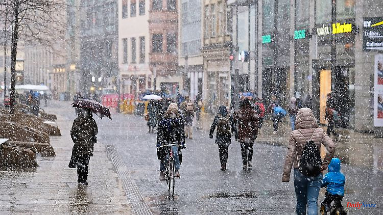
In the north-east and east of the country in particular, people have to dress warmly at the weekend. The first snowfall is there. Meanwhile, it remains milder in the south and west, says ntv meteorologist Björn Alexander. According to the expert, this year could even bring a White Christmas.
ntv: Winter air meets Germany - how is the weather developing?
Björn Alexander: We are currently right between the chairs on the big weather carousel. On the one hand, Scandinavia high "Erik", which transports the cold but dry winter air to Germany on its south side. And on the other side the Atlantic lows, which counteract this in the form of the "Regina" low with damp, mild air. In between, the air mass limit is tightening further, which in turn will ensure the first flakes down to the lowlands.
What are the current forecasts for the first snow?
On the night of Friday, you will probably have to expect a mix of snow, sleet, freezing rain and corresponding smoothness from Schleswig-Holstein to Brandenburg with values around 0 degrees. Otherwise it is milder, with 3 to 8 degrees. It will remain stormy, especially on the coast, where the easterly storm has already caused rough views during the day and in some cases significantly increased water levels.
What is the development afterwards?
On Friday the weather line will shift further to the southwest with snow, sleet and freezing rain and will reach the Harz Mountains, the Thuringian Forest and the Ore Mountains. However, snowflakes down to the lowlands may also be possible in the direction of the Emsland and Münsterland and in the Ostwestfalen-Lippe area.
What are the temperatures bringing us?
In the south and west it remains mild again with peaks of up to 12 degrees on the Rhine, while the values in the area of the borderline weather situation and generally in the north-east and east are quite different. Sometimes it's barely above 0 degrees. And because there is also a brisk wind, the whole thing sometimes feels like minus 5 to minus 10 degrees. After the super-mild and often golden autumn days of late, that's a pretty rapid drop.
Which also goes on at the weekend?
We're not done with this topic anytime soon. Because on Saturday we can expect a strip of snow and freezing rain, which is probably across Germany from the Ore Mountains to the Sauerland. The winter precipitation mix in the Ruhr area and Lower Rhine area cannot be ruled out either.
What does Saturday bring in the rest of the country?
Further north it will remain sunny and only snow showers from the Baltic Sea cannot be ruled out. The south, meanwhile, doesn't notice much of the winter. With temperatures up to 10 degrees, it will mostly rain.
How cold is it in the wintry areas?
In the north-east it even stays with light permafrost around minus 3 degrees or values just above 0 degrees. Sometimes an ice-cold wind blows. And "ice cold" is also the keyword for the nighttime lows. From the low mountain ranges northwards, it will be frosty. In the night to Sunday there are also minima around minus 10 to minus 12 degrees directly on the ground.
And on Sunday?
New rain is coming up in the west, which can change to snow, sleet or freezing rain with ice as it progresses over the center of the country before it gets a little milder. The temperatures on Sunday will reach between 0 and 10 degrees with a sometimes stormy wind. Monday and Tuesday bring us a mixed 2 to almost 11 degrees at times.
A first push of winter that will be followed by a long winter? What do the current long-term forecasts say for the winter?
For December 2022, the bottom line is that the experimental long-term calculations see a development that is too dry and rather mild overall. The forecast - based on the European weather model - currently sees a temperature excess of around 2 degrees. However, with a very cold section that has been appearing again and again for quite some time.
That would be when?
In the period around Christmas of all things. And statistically, it would definitely be time for the White Christmas again. The last snowfall in Germany for the festival was twelve years ago - in December 2010.
How are the calculations going?
Definitely exciting for winter fans. In the European approach in particular, January 2023 is on the cold side, while the current forecasts by the American Weather Service NOAA for both January and February 2023 are consistently on the too mild side.
So good for the heating costs in the summer, right?
If that's actually the case. However: Cold phases can always interfere. Like in February 2021, when a severe cold spell was followed by a record-breaking spring awakening, turning the month as a whole too warm.
What can be generally said about the quality of the long-term calculations?
Of course, such long-term and monthly forecasts are experimental in nature and therefore cannot be compared at all with classic weather forecasts. But at least they tend to follow the right approaches more often. And in times of climate change, a "too warm" forecast for a month per se is a good to spot on approach. If you only take the current year, for example, six months have been too warm, three on average and only one too cold.