While Germany is starting September quite relaxed in terms of weather, severe storms are making the headlines in southern Europe. Extreme weather conditions are also possible in this country in the course of autumn, says ntv meteorologist Björn Alexander. It has to do with the Mediterranean Sea.
ntv: Autumn has already begun for the meteorologists. With what signs in terms of rain for the coming months?
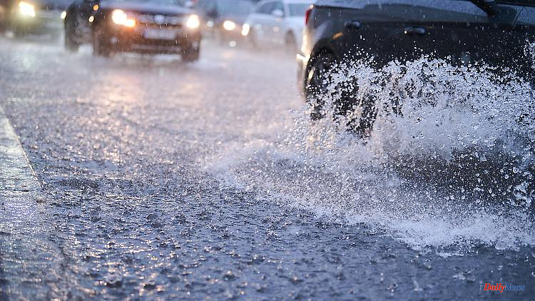
Björn Alexander: Heavy thunderstorms are forecast for the weekend in the southwestern half. In addition, the medium-term forecast actually sees a chance for significant precipitation in many regions next week.
How much rain is in there?
In the middle of next week, the computers will increasingly see lows affecting our weather patterns. The American weather model, for example, calculates that there will be 25 to 50 liters of rain per square meter by the end of next week - sometimes even more. After the experience of the weather changes in the past few months, this is of course on shaky ground. But at least it could be a first trend reversal from the sometimes blatant permanent drought.
What developments are there after that? Key word: long-term forecasts.
The experimental trends also continue to see the options of an average to sometimes even too wet September 2022. That would mean around 60 to 70 liters per square meter on average across Germany.
In addition to the drought, we were repeatedly concerned with the heat in summer. How about that?
Peaks of around 30 degrees are in the running again and again in the coming days. With the possible change in weather, however, the models expect us with significantly more subdued values. And even in the long-term forecasts, September should only be a little too warm. The topic of the great heat would - according to the status now - also be over.
But a mild late summer would be possible, right?
In any case. Late summer or Indian summer, which we like to enjoy from the middle of the month, certainly have ambitions when it comes to warmth. Even if the desire for rain is likely to predominate in opinion these days.
Severe hailstorms have injured many people in Spain and claimed one fatality. Which weather-related developments are emerging in southern Europe? After all, many people are drawn to southern Europe in autumn.
The current storm season is now shifting eastward across the Balkans. Behind them, however, heavy thunderstorms threaten again on Friday and Saturday from France to northern Italy. And unfortunately this is only the beginning of a very stormy autumn.
Why is that?
The hot summer has ensured that the Mediterranean Sea is around three to five degrees warmer than normal. With regard to late summer and autumn, there is significantly more potential energy for possible severe weather and storms. Especially when low pressure areas from the north with colder air find their way down to the Mediterranean Sea. It is therefore actually a bad omen for possible storm forms, such as the so-called Medicanes. So organized storm systems that have similar properties to a hurricane and move in the Mediterranean area.
With effects also up to us?
For us in Germany, too, the much too warm Mediterranean can actually have consequences. In the corresponding weather conditions with low-pressure areas that only move in from the south across the Mediterranean, more water vapor and thus more energy for storms can come into play.
Back to the weather in the following days in this country. What prospects await us?
On Friday, too, it will often be sunny on the edge of the Scandinavian high "Quintin", mostly dry and, especially in the western half, summery warm with 23 to 28 degrees. The east is meanwhile fresher with 18 to 22 degrees.
And on the weekend?
Saturday will be increasingly muggy and warm in the south and west, with occasional thunderstorms. Storms caused by heavy rain, hail and squalls are also conceivable in some cases. The situation will calm down on Sunday and there will only be occasional thunder and lightning.
At what temperatures?
Saturday brings between 19 degrees on the Ore Mountains and up to 26 degrees on the Upper Rhine. On Sunday it will be warmer again with highs of between 20 and almost 30 degrees. The heat mark will be cracked again by Monday at the latest. The river lowlands in the west and south-west are heat poles at up to 31 degrees, while it remains the coolest in the north-east at 21 degrees.
How's the weather going?
Also on Monday initially sunny, before local heat thunderstorms can appear in the west in the afternoon and evening. Tuesday is also often late summer warm with mostly 20 to almost 30 degrees. However, the thundery downpours are becoming more frequent, sometimes more intense, and will probably bring the summer temperatures to a temporary end on Wednesday and Thursday.
What values await us?
Wednesday 20 to 26, on Thursday the majority of the weather computers see a maximum of 19 to 25 and on Friday 17 to 24 degrees. The autumn temperature trend is rounded off by repeated showers, wind, thunder and lightning.


